
Maps: Scales and Coordinates
- 1Print it first. Read it once together and talk it through.
- 2Exercises on paper, then correct together with the answer key.
- 3Next day: a 10-minute review here on screen saves progress.
What you will learn
- 1Use a map scale to estimate real distances between two places
- 2Locate features on a coordinate grid using column letters and row numbers
- 3Identify common map symbols by reading the map key
- 4Describe the difference between large-scale and small-scale maps
Mini Lesson
Maps shrink the real world onto a flat page. Two tools tell you exactly where something is and how big it really is: the map scale tells you how distance on paper compares to distance on Earth, and the coordinate grid lets you name any spot using a letter and a number.
Map Scale
- A scale shows how a small distance on the map matches a much bigger distance in the real world.
- Bar scales draw a small ruler labeled in kilometers or miles. You measure on the page, then read the matching real distance off the bar.
- Ratio scales look like 1:100,000 — meaning every 1 unit on the map equals 100,000 of the same units in real life.
- Word scales say it plainly: "1 cm equals 5 km" or "1 inch equals 2 miles".
- A large-scale map shows a small area in great detail (one neighborhood). A small-scale map shows a huge area with less detail (a whole continent).
Coordinate Grids
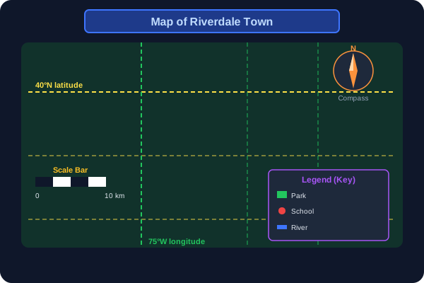
- A coordinate grid is a network of squares laid over a map; on world maps, horizontal latitude lines show how far north or south a place is, and vertical longitude lines show how far east or west.
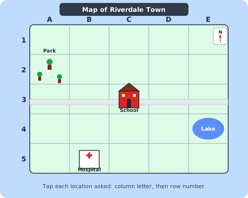
- Columns are labeled with letters (A, B, C, ...) across the top.
- Rows are labeled with numbers (1, 2, 3, ...) down the side.
- A coordinate names the column letter first, then the row number — for example C3 means column C, row 3.
- On a printed road atlas, the index says "Riverdale C3" and the grid square is where you look.
Map Keys and Symbols
- The map key (also called the legend) lists every symbol used on the map and explains what each one means.
- A small triangle often stands for a mountain, wavy lines stand for water, and a tiny tree stands for a forest.
- Different colors can also be symbols — green for parks, blue for rivers and lakes, brown for high land.
- Always read the map title and the map key first, and find the compass rose, the symbol that shows which way is north.
Words to know
scale
A tool on a map that compares map distance to real-world distance, shown as a bar, ratio, or words.
coordinate
A pair like C3 that names a column letter and row number to locate a square on a grid map.
grid
A network of equal squares laid over a map so every place can be named with a coordinate.
map key
A small box on a map that lists every symbol or color used and explains what each one means. Also called the legend.
symbol
A small picture, shape, or color that stands for a real feature on the map, such as a mountain or river.
large-scale map
A map that shows a small area in great detail, such as a single neighborhood or town.
small-scale map
A map that shows a very large area with less detail, such as a country or continent.
Tip: read coordinates as "letter, then number" — column first, then row. C3 is the cell where column C and row 3 cross.
Guided Practice
Exercises
The map shows four labeled places on a coordinate grid. When asked, tap the correct place on the map.
Tap the Park at A2
0 / 4 found · Look at the dashed boxes — tap the right one.
Tap each map element on the diagram as it is described.
Tap the 📏 Scale bar — shows how map distance equals real distance
0 / 6 found · Look at the dashed boxes — tap the right one.
Pick the best answer for each question.
1. A map shows "1 cm equals 5 km". Two towns are 4 cm apart on the map. How far apart are they in real life?
2. On a coordinate grid, what does the coordinate B4 tell you?
3. Which type of map shows the smallest area in the greatest detail?
4. What is the purpose of a map key?
5. A scale of 1:100,000 means that one unit on the map equals how many of the same units in real life?
6. On a town map, the lake is at coordinate E4 and the school is at C3. Which is true?
7. Which scale type uses a small ruler drawn on the map to measure distance?
8. You want a map that shows the entire continent of Africa on one page. Which type of map is best?
Parent Checklist
For the parent: after correcting together, check off what your child has really understood